We have been very fortunate to obtain a copy of the report by Robin Witter on the last extensive inspection of Butterley Tunnel, which took place on Saturday 20th October 1979. We’re delighted to be able to reproduce it here in full. Sections in quotation marks formed part of a script (possibly from a talk):

The start of the original tunnel at the west end, showing wooden supports.
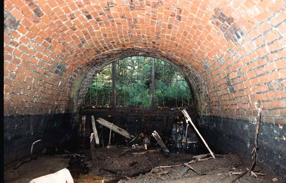
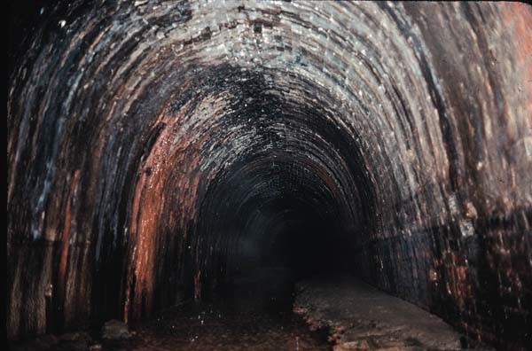
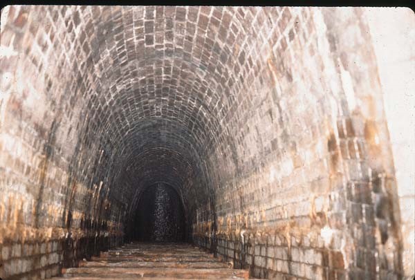
Butterley tunnel, eastern portal, looking out, with little water
The Illustrated Report
The Eastern (Golden Valley) portal is low down in an approach cutting which is almost dry. A feeder from the Butterley reservoir comes in from the northern side. The entrance has been built up to a height of about 18 inches with wooden boards etc (giving a drop in to the tunnel) to remainder of the entrance being barred but with a hinged gate and secured by a nut and bolt of about one inch diameter. The inside of the tunnel has a thick silt layer with only the merest of water channels running between it. Height from silt layer to arch at the entrance is about 6ft.
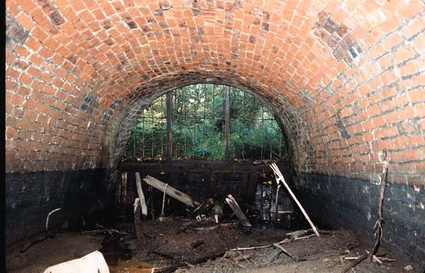
Eastern portal, looking out. Little water.
It is known that in wet weather there is a substantial flow of water along the feeder which fills the approach cutting and runs back into the tunnel, putting it into water above the silt up layer.
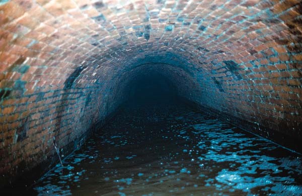
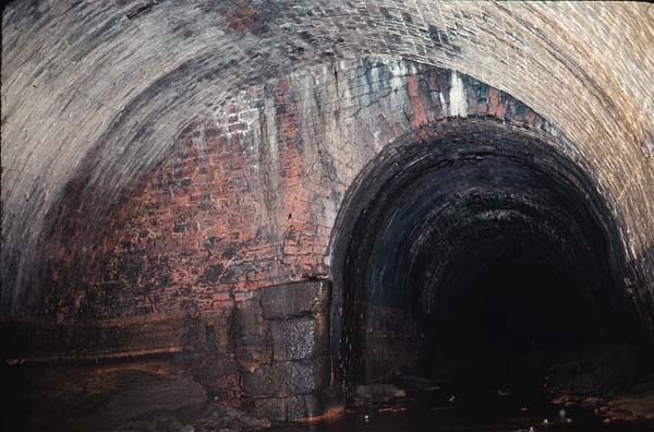
Looking into tunnel from Eastern portal. Water almost up to top of watermark.
Looking into tunnel from Eastern portal. Water almost up to top of watermark.
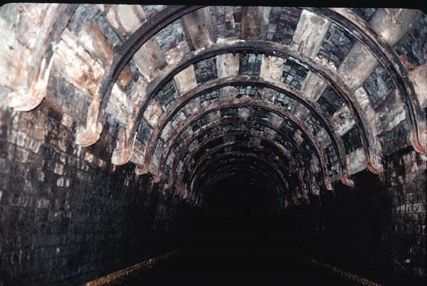
There are numbers along the northern wall, commencing at two (one being absent) at approximately 22 yard intervals: presumably chains. Between 2 and 3 there is wooden shoring horizontally across the Tunnel with head room to pass beneath, the tunnel height appearing to rise somewhat beyond this. All as far as could be seen 150 yards total from the entrance appeared to be silted and with brick lining across the arch and sides. The brickwork was not in good condition but none had fallen out.
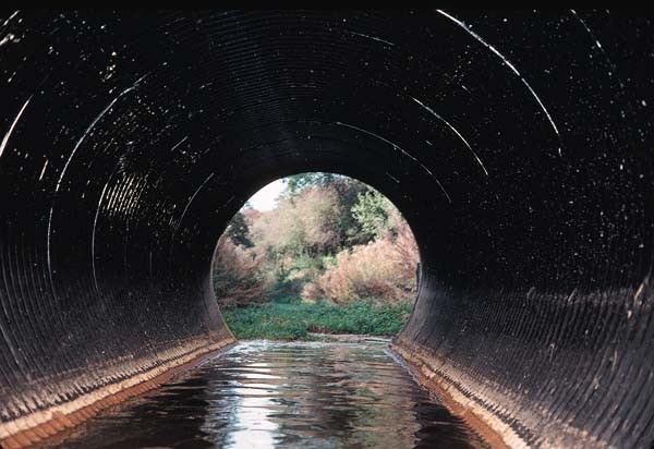
Western entrance is obscured by the recently constructed Ripley bypass which has extended the extended Tunnel a further 30 yards or so within a 5 ft diameter conduit of corrugated steel lined concrete containing some 18 inches of water in the invert.
Road extension, “literally only 20 yards”.
Road extension, “literally only 20 yards”
This gives straight to the main tunnel, the portal now being obscured. Distance plaques again measured at 22 yard intervals are along the northern wall numbers one to 10 being seen. The first hundred yards or so of the tunnel arch have steel and timber reinforcing over the brick lining. This was presumably additional reinforcement inserted when the tunnel was extended from the originally constructed 2,966 yards to 3,063 when the railway was built over the top.
Rail extension, curved steel supports backed by wood.

Lower red brick arch looking West – still railway extension?
“West end, extended for railway and then again for road, last is “just a bit of metal” [Armco tube]. Can still clearly see extension for railway, and clearly obvious which it is. Much higher as I remember and totally different in its style. Chainage markers are still there (well, they were, I took one). I think the cast iron ones are the authentic markers. From western end could get literally half way before it was “completely filled in”. Must have fallen in after they’d put the pipes in. I don’t remember seeing any boats down there.”
“Commencement of original tunnel” Wooden supports.
Water depth in this stretch was at three to four feet; width at water level 8ft 6in; height to roof arch from water level about eight feet. At marker 10 the steel reinforcing across the arch discontinues, the arch and sides being entirely brick lined and in fairly good condition. A few stalactites both of limestone and ironstone and also ‘curtains’ of both were in evidence in this area.
Lime and iron deposits, silt.
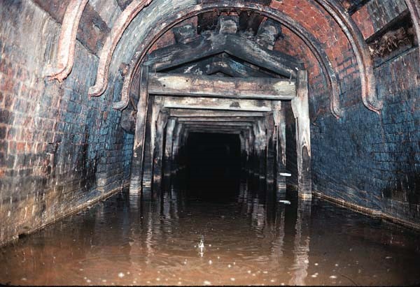
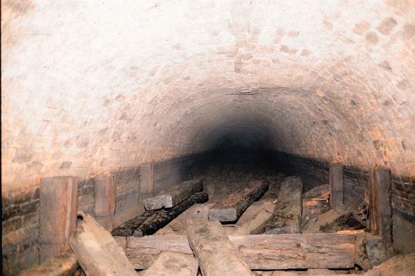
There were several stretches 20 to 30 yards long with timber trestle shaped reinforcement to the walls and roof and one of horizontal beams presumably preventing inward bulging at of the walls only.
At about 400 yards was a ventilator shaft about 35 feet to the surface. The shaft is visible in the middle of the scrapyard on the surface and is covered with a mesh grill, to the west of Butterley reservoir. The base of the shaft has a modest amount of rubble, necessitating a straightforward portage and causing a six inch drop in water level the lower level being to the West. Roof height remained about eight feet from the water level. There is no subsidence though occasional bulges to the walls and roof.
From base of ventilator shaft.
From base of ventilator shaft.
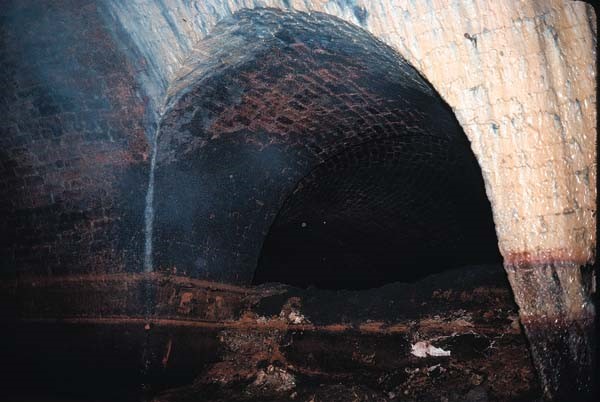
At about 600 yards is a brick lined adit about 20 yards long with water cascading in from above. At water level this has timber cross reinforcing pieces at regular intervals. A shaft from this adit is located on the surface in a depression with padlocked steel door just the west of the reservoir. It presumably represents a feeder from the reservoir, the water flowing westwards.
Side adit to feeder from Butterley Reservoir. North Wall. Wooden slats along bottom, no idea what they’re for. Water cascading in distance.
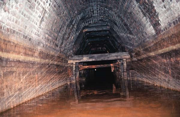
From the same point looking along the tunnel. Low cross wooden supports sloping left.
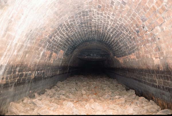
From here the water depth decreased with silt rising towards the surface and at the sides protruding above the water level. The silt is throughout a deep ochre or rust colour. Water depth decreasing to six inches or less.
At approximately marker 40? (900 yards), the tunnel increases to about three times its previous width (ie 25 ft) and increases in height to some 12 feet for about 40 yards length. On the south side is one dry tunnel of substantial dimensions and a second probable Tunnel of similar dimensions, with the entrance bricked off and at the extreme east end of the widened area a low tunnel in water if possibly for drainage or possibly a previous tub boat tunnel. [Ties in with diagram last tunnel is diverted water from Butterley Carr Pit.] The whole area was deeply coloured red ochre and was obviously the underground loading area for the Butterley Company located above at this point. The whole area is considerably silted and all, including what could be seen of the side tunnels, is brick lined.
West end of wide hole, narrowing to normal tunnel width; silt, dressed stones.
Wide hole, connecting tunnel, base dry inside, appears to curve to left.
Mostly it is dry from the roof as the previous length of tunnel had been even when passing under the reservoir but the western end of the widened area has mixed lime and ironstone deposits overlaying the brickwork.
The tunnel then recommences at its original dimensions for a very short distance about 20 yards where it becomes totally dewatered by being raised some 2 1/2 ft from the previous water level, the whole being covered by a loose stones. The water channel is presumably culverted beneath.
Dewatered section.
There is a short 10 yard widened stretch and the tunnel continues out of water from this point (about nine hundred and fifty yards: or marker 43) onwards at least to marker 50 (1,100 yards) with several areas of timber shoring to the roof and walls, all of which are brick lined, no collapses being evident, the brickwork being in fair condition despite several bulges. At marker 45 there are two about three inches apart (an interesting speculation could be that the distances between the markers up are not one chain (22 yards) but greater) and as it is known that the numbers both increase from the East and West ends from 1 that this represents the halfway point. This however is unlikely, but I can think of no reason for two markers at almost the same position.
From the commencement of the culverted section the western end could be seen the bore of the tunnel being very straight. From hereafter it could not mainly on account of the raised level this being some five feet from arch to the rubble surface.
Culverted section, dismantled or broken supports. “Didn’t fancy going any further than this”. Bulge in roof.
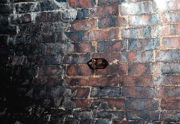
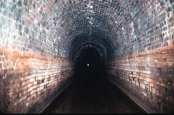
Marker 12. Note brick bonding same throughout.
Further inspection beyond 1,100 yards was not attempted, but as far as could be seen (approximately 100 yards) and the rubble layer continued, the arch and roof were up brick lined and there were no falls.
Light emanating from the shaft at about 1,300 yards (known to be clear to the bottom and with water) could not be seen.
There is also another, more recent, report and photographs made by Tina Cordon between October and November 2006, which can be viewed here (external site).